| |
| |
|
|
|
| |
| |
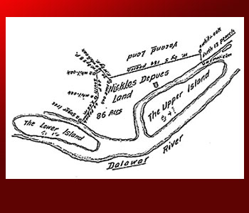
1730 -- PROPERTY
SURVEY
Truly unique icons are among the
rarest of finds in early Pennsylvania survey maps.
We have such an icon in the map produced by surveyor
John Chapman on behalf of "Nicklos Depues". So
what's the significance of this singular icon that
appears under the letter "p" in the recorded
surname? We already know that cartographers of the
period had previously developed a set of icons
specific to Indian towns, missionary towns, forts
and mills. Apparently, surveyor Chapman decided
that an Indian trading post required a new type of
locational icon.
Also notable in this survey map is the parcel's
property size, cited as a mere 86 acres. This
observation then begs the question: "Why are a
paltry 86 acres being surveyed when this merchant,
just three years earlier, had concluded the purchase
of a 3000-acre tract?" As it turns out, surveyor
Chapman had the sad duty of informing Dupui that his
earlier expansive purchase was regarded as illegal
per turn-of-the-century Pennsylvania law:
| that if any person presume to buy any
land of the natives within the limits of the
province and territories without leave from
the proprietary thereof every such bargain
or purchase shall be void and of no effect. |
A quandary, to be sure, but as Dupui had already
established his area trading post facility, he had
no choice but to accede to the surety of a new
survey and to accept a new, albeit inferior, real
estate arrangement. Three years later, in September
1733, Dupui would finally tender payment for this
particular parcel and its adjacent islands (procured
from the Penns' land agent, William Allen), for the
token sum of five shillings.
Purely as an matter of interest, it should be noted
that the aforementioned icon appears on the survey
map at a place that actually corresponds to the
location of a fresh-water spring (confirmed by both
recourse to LiDAR mapping and by a subsequent site
visitation). Further, the western boundary of
Dupui's parcel coincides with the position of the
aptly named Mill Creek, the waterway upon which
Dupui established his local grist mill operation.
|
|
| |
|
| |
|
|
|
| |
|
|
|
| |
|
|
|
| |
|
|
| |
|
|
|
|